County Line or Watershed? Reading Two Different Edges
Learn how a county line differs from a watershed, read both on a map and see why their paths may cross without either being misplaced.
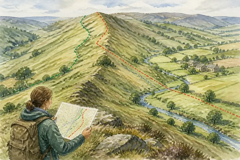
A county line and a watershed can cross on the same hillside without either being wrong. To read a county line or watershed clearly, ask what each edge describes: one marks an administrative division, while the other traces the land that drains towards a watercourse.
They may follow the same ridge for a stretch, then part company because the county edge serves one purpose and the watershed another. Here are seven ways to tell them apart and understand what their relationship says about a place.
1. A county line separates areas of administration
A county line marks where one county ends and another begins. Depending on the area and map, county boundaries may help define local government, electoral arrangements, records or a recognised regional identity. The line is about jurisdiction or naming, not necessarily the shape of the land.
Its path may follow a ridge, stream, road, field edge or a line across open ground. Those features can make a boundary easier to recognise, but they do not make it a watershed. A county border might continue across a river, even though the river collects water from land on both sides.
On a map, look for a boundary symbol in the legend and read its label carefully. A county line is often distinguished from parish, district or property boundaries. If several kinds of boundary appear close together, their different line styles matter more than how closely they seem to follow a natural feature.
2. A watershed follows the high ground between drainage areas
A watershed, also called a drainage divide, is the dividing line between land that drains towards different river systems or outlets. Rain falling on one side generally flows towards one stream or basin; rain on the other side drains elsewhere. The divide often follows higher ground, but it is a hydrological boundary rather than an administrative one.
The word “watershed” can also mean the whole area draining into a river or other outlet. On a map, check whether it refers to that catchment area or to the line around it. The distinction prevents a common muddle: a watershed boundary is the edge of a drainage basin, while the basin itself is the land enclosed by that edge.
Contours, spot heights, streams and the shape of the relief can help you interpret the divide. A ridge may send water down opposite slopes, but not every high point is part of the same watershed. Drainage can also be affected by features that are difficult to read from a broad regional map.
3. Similar-looking lines can describe different things
Both lines may appear to trace a ridge, so an overlap on a map can suggest that the county boundary was chosen to match the drainage divide. Sometimes the features do coincide, at least for part of their length. That visual agreement does not establish that the lines share a purpose or remain together elsewhere.
Map scale adds another complication. A small-scale map simplifies bends and minor streams; two nearby lines may appear to merge when they are actually separated on the ground. A detailed map can reveal more of the terrain, but its boundary symbols and labels still need to be checked against the legend.
Imagine a county border running along a broad ridge, then turning east towards a settlement, while the watershed continues north around the head of a stream. The county line may reflect an administrative arrangement; the drainage divide follows the land’s route for water. Both lines are coherent, although they answer different questions.
4. A boundary can cross a catchment without dividing its drainage
When a county line crosses a stream or passes through a drainage basin, the water does not change course at the border. A brook can rise in one county, cross into another and join a river further downstream. The county line divides administrative territory, while the watershed contains the connected land that supplies the watercourse.
This is useful when reading place information. A village may be described as belonging to one county even though nearby slopes drain towards a river associated with another. The local identity and the physical drainage pattern can both be accurate without matching neatly.
The same principle applies in reverse: a watershed may cross several counties. A catchment map can help explain where water flows, but it cannot by itself identify which local authority or county a place belongs to.
5. Each edge answers a different practical question
A county boundary helps answer which administrative area a place falls within. A watershed helps answer where rainwater gathers and which streams or rivers receive it. Neither line substitutes for the other; choose the one that matches your question.
- Observation: The map legend labels a line as a county boundary. If you need a county location, then use that line; otherwise, do not treat it as evidence of drainage.
- Observation: The map shows a catchment edge or drainage divide. If you are tracing where water flows, then follow that edge; otherwise, use an administrative boundary source for county status.
- Observation: A stream crosses the county line. If you are following the watercourse, then continue along its channel across the border; otherwise, do not use the stream to assign a county.
- Observation: The county line appears to follow a ridge. If you need to know whether the drainage divide also follows it, then compare relief and streams; otherwise, read the administrative line according to its legend.
- Observation: Two maps show apparently different boundaries. If their legends identify different features, then treat them as distinct; otherwise, check scale, date and boundary type before drawing a conclusion.
- Observation: A label sits beside rather than directly on a line. If its placement is unclear, then trace the symbol and consult the legend; otherwise, use the line itself rather than the label position.
It is not worth trying to infer a county solely from which direction a stream flows. That may be an interesting clue about the landscape, but the administrative line may run elsewhere.
6. The map’s purpose shapes how each line is shown
A regional atlas may emphasise county divisions, while a river-basin map gives more prominence to catchments and streams. A general topographic map may show terrain and watercourses clearly but make administrative boundaries less prominent. The appearance of a line reflects the map’s purpose as well as the feature it represents.
Check the legend before comparing positions, then note the scale and date if supplied. A map that simplifies the landscape may suit orientation but be too general for resolving a close boundary question. If exact administrative status matters, use an authoritative current boundary source; if the drainage divide matters, choose a map or dataset designed for catchments.
Labels can mislead when placed for legibility rather than directly over the feature they name. Trace the symbol itself instead of assuming that a label’s position identifies the line. Where the line is faint or interrupted, avoid extending it by guesswork.
7. Readers often ask how the two boundaries relate
Does a county line always follow a ridge?
No. A county line may use a ridge in one place and cross lower ground elsewhere. Its defining role is administrative, so the terrain does not have to provide a continuous natural divider.
Does every watershed follow the highest visible ridge?
A drainage divide often follows higher ground between neighbouring catchments, but a simplified map may hide small changes in relief or drainage. Read contours and stream patterns together rather than treating every hilltop as a divide.
Can one stream flow through more than one county?
Yes. A stream can cross an administrative boundary while remaining part of the same connected drainage system. The county changes at the boundary; the watercourse continues along its channel.
Which map should I use to check a disputed-looking line?
Use a current map suited to the question: an authoritative administrative source for county status, or a catchment map for drainage. If the lines appear to diverge, compare their legends and scales before deciding that either has been drawn incorrectly.
Separate edges make a clearer picture
Reading a county line or watershed is easier once you stop asking which one is the “real” boundary. One describes an administrative division; the other describes the land’s drainage. Their paths may meet, cross or travel apart, and each can still be read correctly.
When a map presents both, trace each line on its own terms: check the legend for the county edge, then use relief and watercourses to follow the watershed. If the question concerns a place near a border, identify the boundary type before using the map to describe its county or its drainage.